University of Redlands
July 10-14, 2023
San Diego Convention Center
Visit us at Booth #212
"Learn, reconnect, and discover the latest advances in GIS technology when the Esri User Conference returns to San Diego. Join thousands of users from around the globe and get a front-row seat for a look at the future of GIS capabilities." - Esri
To attend the conference events, you must be registered.
Register for free digital access to the UC (University of Redlands Students, Faculty, and Staff, Only)
Students! Register for a free one-day pass or pay the special University Student rate for the entire UC ($150).
Faculty and Staff: Register for the in-person UC and/or the Education Summit.
Note that full complimentary passes for the in-person UC and Education Summit events are limited to faculty and staff.
Note the event FAQs.
8:30 a.m. – 9:30 am | "Saving Our World with Student-Centered Spatial Storytelling"
Marriott, Grand Ballroom 3
Dr. Steven Moore, Director Center for Spatial Studies
3:30 p.m. – 5:30 p.m. | Academic GIS Fair | Booths A120 and A121
San Diego Convention Center, Sails Pavilion, Third Level – Ballroom 20 Lobby
4 p.m. – 6:30 p.m.| Map Gallery Reception
San Diego Convention Center, Sails Pavilion – See below for Map Gallery entries
8 a.m. – 6 p.m. | Map Gallery
San Diego Convention Center, Sails Pavilion
9 a.m. – 6 p.m. | Expo, Booth #212
San Diego Convention Center Exhibit Hall
8 a.m. – 6 p.m. | Map Gallery
San Diego Convention Center, Sails Pavilion
8:30 a.m. – 9:30 a.m. | "Prioritizing Pavement Improvement Jobs Using Analytics"
San Diego Convention Center, Room 29 B
Kyle Wingson '24
9 a.m. – 6 p.m. | Expo, Booth #212
San Diego Convention Center Exhibit Hall
10:00 a.m. –11:00 a.m. | "Wowing the Stakeholders with Dynamic Reports"
Marriott, Pacific Ballroom 14
Georgia Leonard '24
2 p.m. - 3 p.m. | Expo, Booth #212 | New Spatial Business Book
San Diego Convention Center Exhibit Hall
Spatial Business: Competing and Leading with Location Analytics
Thomas A. Horan PhD, Janes B. Pick PhD, Avijit Sarkar
MEET THE AUTHORS AND GET YOUR BOOK SIGNED!
Books available for purchase: Esri Bookstore Open daily during the Esri UC
2:30 p.m. - 3:30 p.m. | "Digital Divide Disparity: An Exploratory Look"
San Diego Convention Center, Room 29C
Marisol Carranz '23
5 p.m. - 6 p.m. | MSGIS/MGIS Alumni Reunion
6 p.m. – 8 p.m. | University of Redlands Reception - Alumni & Friends
Roy’s San Diego Waterfront
Marriott Marquis, 333 West Harbor Drive, San Diego
Pick up an invitation for this exclusive event at our Expo Booth #212
Registration required
8 a.m. – 1:30 p.m. | Map Gallery
San Diego Convention Center, Sails Pavilion
9 a.m. – 4 p.m. | Expo, Booth #212
San Diego Convention Center Exhibit Hall
Check out Esri's ArcGIS Indoors Conference Map
County of Marin Restrictive Covenants Project
Michelle Jennings & Susanne Ma
Racial discrimination is a dark stain on the fabric of American history and current events. From the slavery of Black people that culminated in the U.S. Civil War, postwar civil rights battles, the Asiatic Barred Zone Act of 1917, to today’s Black Lives Matter movement, those discriminated against, and their allies continue to spotlight and fight for corrections in socio-economic systems that are unjust and inequitable. Among them, was the practice of racially motivated housing discrimination through Restrictive Covenants that began in the early 1900’s. The 1948 Supreme Court ruling on Shelley v. Kraemer made racially restrictive covenants unenforceable and the Fair Housing Act of 1968 outlawed the practice. Today, counties across the U.S., including the County of Marin, have launched initiatives to discover and redact such covenants.

Mapping Marine Mammals: Species Distribution Model for the Southern California Bight
Tanessa Hartwig, Douglas Flewelling, Lei Lani Stelle
Marine mammals are a taxa of conservation concern, yet many species are data deficient. This project: 1) assessed two algorithms, Generalized Additive Modeling and Maximum Entropy, for accuracy, user-friendliness, and ability to determine marine mammal habitat relationships; and 2) created a Modelling 101 Resource Kit to provide species distribution modelling guidance to undergraduate marine biology students. ArcGIS Pro and R Studio were used to complete the modelling.
Veteran Cemeteries of Waushara County
Hugo Ortiz, Ruijin Ma
Due to the lack of a central data depository and inefficient coordination between the private sector, municipal and local government, the public has difficulty in searching for veteran family members buried in local cemeteries. This project works with Waushara County, Wisconsin in developing a web GIS application to provide a central database management system and a unified interface for the public to access information about their veteran family members buried in cemeteries within the county. The model is applicable to all the cemeteries in the county and to other cemeteries throughout the United States that include non-veteran burial sites. It provides the leading entity with access to continue to build out the database for public use and to further enhance the capabilities of the model.
Industry Clusters
Thomas Horan, Mattie Anders UNM, & Chad Lopez
Today’s economic map consists of what Harvard Business School professor Michael Porter refers to as clusters: critical masses – in one place – of unusual competitive success in a particular field. The enduring competitive advantages in the global economy rely increasingly in local things – knowledge, relationships, motivation – that distant rivals cannot match. Clusters reveal that the immediate business environment outside companies play a vital role, just as what happens inside companies, and how the two contribute to creating competitive advantage. This study examined industry medical device manufacturers in Minnesota and the Southern California/Baja region.
 Online Activities and Purposeful Internet Use in the United States: A Pandemic (2021) Outlook
Avijit Sarkar, James B. Pick, Owen Giron
This study analyzes geographic patterns and socioeconomic influences on purposeful internet use by American internet users during the COVID-19 pandemic. Mapping and cluster analysis reveals that the lowest levels of online activities takes place in U.S. states that often had higher proportion of urban population and higher median age. Remote workforce plays a key role in explaining disparities in the extent of internet use and the consequent digital divide in the United States.
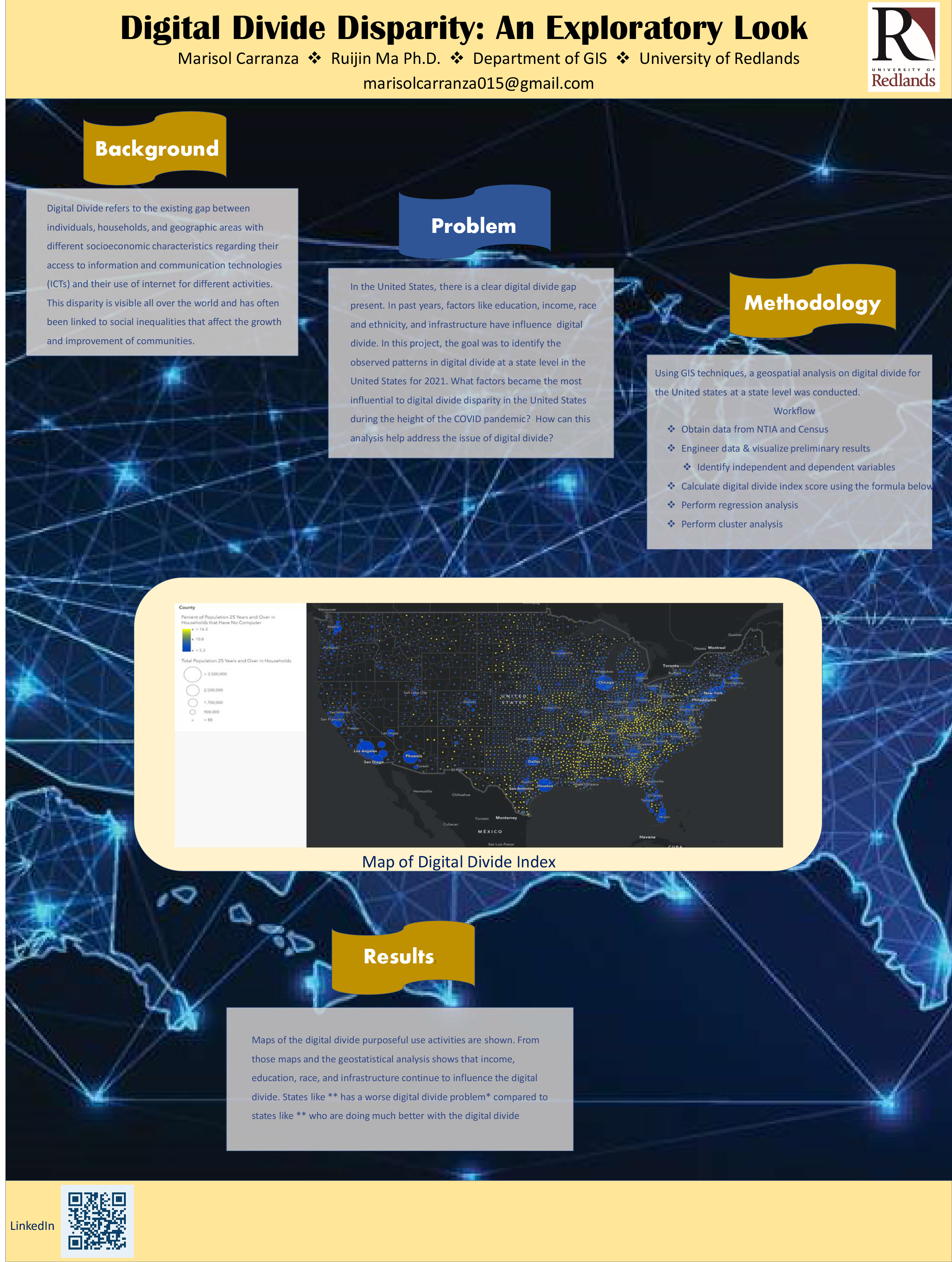 Digital Divide Disparity: An Exploratory Look
Marisol Carranza, Ruijin Ma
Research on digital divide has focused primarily in exploring the gap in accessibility of information and communication technologies amongst different demographic and socioeconomic groups. Over recent years, the focus of digital divide research has shifted towards exploring patterns of Internet usage amongst varying demographics to help formulate more adequate digital divide policies. This project analyzed the digital divide problem at its second level- Internet usage and skills. Through statistical methods of clustering analysis, areas of high and low Internet usage clusters in terms of geographic, demographic, and socioeconomic attributes were identified throughout the United States at a state level for the most recent 2021 internet usage data available. Relationships between demographic and socioeconomic factors on purposeful Internet use were analyzed through spatial autocorrelation and ordinary least squares regression analysis. ArcGIS Spatial Analyst and Spatial Statistics tools including density, multivariate, spatial autocorrelation, and hotspot analysis tools were used to carry out the spatial analytical work.
 A Web Application for Climate Impacts in Redlands, CA