Are there movie preferences across America? What does food accessibility and inequality look across the Inland Empire? These are just a few of the questions and discussions presented at the Spatial Symposium on April 12 at the University of Redlands.
The U of R celebrated spatial learning, research, storytelling, and community service conducted by students, faculty, administrators, alumni, and campus programs at its annual Spatial Symposium on April 12.
In an interview with the Bulldog Blog, Steve Moore, director of the Center for Spatial Studies, provided insight into the importance of Geographic Information Systems (GIS) and spatial studies.
BB: Why is the Spatial Symposium important for both students and the U of R community?
SM: The Spatial University Symposium provides an opportunity for students, faculty, and staff to share spatial projects they have accomplished over the past year. We hold it near the end of the academic year so that students have an opportunity to share their work. To me, it’s particularly important for students to have a chance to present their spatial projects in a professional context. I love seeing everyone’s posters, StoryMaps, and lightning talks.
BB: What are some skills students take away from the spatial studies program?
SM: GIS allows students to combine geographic data from many different sources. So, I find it to be an excellent tool for empowering people to conduct research on questions that are important to them. As such, GIS helps students ask questions, challenge assumptions, and propose solutions to significant problems that are challenging our world. GIS democratizes the research process. Not too long ago, only highly trained experts could do GIS. Today, anyone with a brief introduction to available tools can jump in, conduct research, and solve problems.
BB: Why is GIS important in academics or in daily life?
SM: We face pressing problems that need to be addressed, not only by scientists and politicians, but everyone: global climate change; diversity, equity, and inclusion; warfare and other kinds of conflict; environmental justice; educational justice; homelessness; and many other issues. GIS provides a way to bring different perspectives together and communicate potential solutions to the challenges we face.
The power of GIS was apparent in the COVID pandemic. We could track where outbreaks were happening, act to slow the progression of the disease, and allocate resources to help those in need. GIS is critical in addressing environmental issues. With GIS, we can track the impacts of urbanization, for instance, how pollutants are distributed across geographic areas (and across people in different socioeconomic groups), and plan for improving the resilience of communities to climate change. GIS has also significantly changed how we view the world. Maps of the past can be re-drawn. We can recover the history and impact of marginalized peoples and communities. We can put back onto the map what has been excluded by negligence and calculated exclusion.
BB: How do GIS and spatial studies help students with their academics or for their future careers, and can this be applied to other subjects/careers?
SM: GIS and location analytics are growing fields. We are blessed to have the largest GIS and location data providers right here in Redlands: Esri. Jack Dangermond, Esri’s founder and president, was raised in Redlands and has been very generous to the University with monetary and software donations. As a result, we are uniquely positioned to help students pursue internships, careers, and graduate education in fields that use GIS and location analytics. Students who minor in spatial studies find internships and jobs with Esri, environmental consulting firms, the many businesses who rely heavily on GIS in their operations and marketing (e.g., Walgreens, Travelers Insurance, FedEx, UPS, Amazon), governmental agencies and tribal governments, and conservation and human-service nonprofits. Many others go on to graduate study in geographic information science, cybersecurity, geospatial intelligence, environmental science, digital humanities, and many other disciplines.
The symposium honored graduate and undergraduate student works. The Bulldog Blog interviewed two award winners. Debapriya Paul ‘22, who won the Poster and StoryMap Award for her StoryMap titled “Food Access in San Bernardino County” with her advising Professor Douglas Flewelling. Hannah Jugar ‘23, who won the Undergraduate Tomlinson Prize for Excellence in GIS and Poster and StoryMap award for her StoryMap titled “Ecological Succession in the Bearpaw Reserve.”
Debapriya gave us insight into her StoryMap and what this award means to her...
BB: When and why did you become interested in GIS?
DP: GIS has always fascinated me with its ability to see things holistically and systematically with the science of geography. Solving real-life problems by mining information and bringing understanding to complex datasets is one of the most impactful aspects of GIS that excites me. Intrigued by the language of maps back in 2014, I was drawn toward identifying patterns and relations between scientific layers of information. This has led me through my career path since, and I have developed a passion for GIS that drove me to continue my education at the University of Redlands
BB: What is important to you about your StoryMap?
DP: My StoryMap presents an interactive story of food access in San Bernardino County, California. It interweaves different pieces of the Major Individual Project I worked on- the purpose of the research, the crucial data elements, the methodology, and the results. The application served as a powerful tool to narrate the conclusions of the project.
BB: What does this award mean to you?
DP: This moment is special to me as an international student. It was a very life-changing experience to move to a different continent with dreams and aspirations. It feels very rewarding after all the hard work on the project, to know that the StoryMap and the poster have told a story that is impactful. This award validates the drive and passion I have for GIS.
BB: Has spatial studies/GIS helped you in other academic subjects or daily life?
DP: Of course, it has! Thinking spatially has driven major decisions in my daily life. For example, using spatial analysis tools to weigh a diverse combination of conditions to decide on a suitable location for my next apartment, leveraging the power of location analysis to navigate around the city! For me, GIS has enabled a different perspective of looking at life!
BB: Are you interested in pursuing a career in GIS?
DP: Yes! To be able to pursue a career in GIS has driven me throughout my journey. I am very excited to have joined ESRI as a Product Engineer for the ArcGIS Online team in January 2023. It has given me the opportunity to make meaningful maps for decision-making and continue exploring the robust application of GIS every day.
BB: Is there anything else important you would like to share?
DP: I would like to express my gratitude to my advisors, Professor Flewelling and Jennifer Bell. I appreciate their time and effort; I owe this award to them!
To view Debapriya’s StoryMap, click this link.
Hannah gave us insight into her StoryMap and her passion for GIS...
BB: When and why did you become interested in GIS?
HJ: I was not introduced to GIS until I took David Smith's intro course when I was a sophomore in the Covid school year. David's enthusiasm for GIS made me realize how this technology and spatial thinking can be applied to solve solutions in every industry. I learned quickly that GIS would be a helpful tool in whatever career path I chose.
BB: What is important to you about your StoryMap?
HJ: I have made numerous ArcGIS StoryMaps for class projects and research, and to showcase the University of Redlands' sustainability progress. I interned under Dr. Wendy McIntyre last summer in the Summer Science Research Program where I analyzed the Ecological Succession in the Bearpaw Reserve. This project included many pictures, videos, and maps; all perfect components for creating a StoryMap. During my work study, Professor Valerie Rountree assigned me to create a "Sustainability at the UR" page on the EVST Department Website, which required me to reach out to various faculty and staff on campus to ask about sustainability. I was impressed with the many climate action efforts on campus, as this was all news to me. I thought the best way to raise awareness of these sustainable efforts would be through StoryMaps. StoryMaps were a great way to implement my interests in GIS, map-making, and photography.
BB: What does this award mean to you?
HJ: Receiving the Roger Tomlinson Award and StoryMap Award felt like the cherry on top of my spatial experience at Redlands. Since my first introduction to the topic, I knew how valuable and applicable GIS was. I made an effort to pick my professors' brains with questions about the lessons and looked at every project, assignment, or situation from a spatial perspective. It was a heartwarming experience to see my work acknowledged by Jack Dangermond, my golf team, golf coaches, my parents, and the faculty of the Center for Spatial Studies.
BB: Are you interested in pursuing a career in GIS?
HJ: I am interested in pursuing a career using GIS. I will be starting a summer position as an Ecologist Intern for Great Ecology, an ecological consulting firm in San Diego, CA. Eventually, I hope to work on a project applying GIS to make the golf industry more sustainable as the effects of climate change intensify. GIS has great potential to analyze and plan climate change adaptations for golf courses.
To view Hannah's StoryMap, click this link.
The symposium also featured lightning talks given by students, faculty, administrators, and alumni. Topics include drone mapping of the U of R SURF garden, mapping environmental justice of Los Angeles air quality near warehouses, GIS solutions for the hotel industry, and many more. In addition, the symposium featured keynote speaker Professor Jennifer Tilton. Tilton is a professor of Race and Ethnic Studies at the U of R and works to combine geography, history, and anthropology to explore how race was built into space, politics, and public policy in the United States. Tilton presented the keynote, "Mapping the Color Lines: Segregation & Community Formation in the Inland Empire."
"A People's History of the Inland Empire" is a digital archiving and mapping project that aims to make the history of communities of color more visible in the region and to create maps that help us think about the ways our past shapes our communities today. The community-based project has built a georeferenced digital archive and has mapped historic census data from the early 20th century so that the project team can document historic patterns of racial segregation and bring historic communities to life. Project members will use these maps to show the contested social process of building racial segregation and how communities formed and fought for racial justice within those color lines and will invite IE students, scholars, and residents to use some of these newly published maps to explore the history of their own communities.
To learn more about “Bridges That Carried Us Over” Project, click this link.
Awards:
Presented by Professor Fang Ren, Tiffany Keller and Belinda Enriquez were awarded the Center for Spatial Business Student Excellence Award.
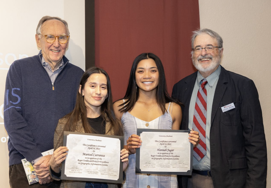
Presented by President Krista Newkirk, Hannah Jugar was awarded the Undergraduate Tomlinson Prize for Excellence in GIS.
Presented by Jack Dangermond, founder of ESRI, Marisol Carranza was awarded the Graduate Tomlinson Prize for Excellence in GIS.
Presented by Steve Moore, the winners of the Poster and StoryMap Award include:
“Web application for Monitoring Hopi Sight Location” by S. Quentin Olive-Larson, Wesley Bernardini and Douglas Flewelling
“Food Access in San Bernardino County” by Debapriya Paul and Douglas Flewelling
“Ecological Succession in the Bearpaw Reserve” by Hannah Jugar
To learn more about the symposium or to view Posters and StoryMaps presented, click this link.