In a first for the Center for Spatial Studies, the 2022 Spatial University Symposium was offered in a hybrid format on Wednesday, April 6—in person in the Casa Loma Room on the Redlands campus and streamed via Vimeo. The annual celebration of spatial learning, research, and community service featured University of Redlands students, faculty, and staff who presented their geographic information systems (GIS) research.
This year’s symposium focused on storytelling. The event featured posters, presentations, and StoryMaps—an online platform developed by Redlands-based GIS software company Esri that allows anyone to tell immersive stories about spatial data, research, and information.
“Public and political responses to the global warming and COVID-19 crises have demonstrated that explaining science through charts, graphs, maps, and scientific arguments isn’t enough to drive public sentiment, policy, or community action,” Center for Spatial Studies Director Steven Moore said. “Good storytelling is also needed. StoryMaps provide an excellent vehicle for touching the hearts and minds of audiences we need to reach.”
GIS around the world
More than a dozen faculty, staff, students, and research partners presented seven lightning talks that provided insight on recent projects and research. The talks covered topics from wastewater-based epidemiology to strategies in business. Faculty from the MS GIS program and students from the School of Business & Society highlighted the impact of University programs.
In his talk, Professor of Environmental Studies Daniel Klooster described the environment in which U of R students map the rainforest. “We are off the grid, sometimes it rains so hard the power supply gets flooded out, sometimes the converter between the solar panels and the research station is burned out, there are not enough computers for all of the students, the drones fly into trees that fall into rivers. And yet somehow it works amazingly well,” he said.
School of Business & Society students Laura Krenek ’22 and Kristii Krugel ’22 discussed the impact location intelligence has on global business through their experience in the School’s Global Consultancy program. The MBA program ends with a capstone that allows students to implement their skills by analyzing and solving business problems. “For those brave enough to apply, you can do this with a live client,” Krenek said.
Honoring commitment and passion
Similar to last year’s virtual symposium, the event featured a virtual space dedicated to posters and StoryMaps. Participants explored the research projects and voted for their favorite presentations.
The winning poster was Understanding the Deep Sea Coral and Sponge’s Database through an ArcGIS Learn Lesson by MS GIS student Ashlee Robinson ’22. The focus of Robinson’s project was to make data from the National Oceanic and Atmospheric Administration accessible and understandable to everyday users.
The winning StoryMap was PanaMapping: Mapping To Conserve The Rainforest by College of Arts and Sciences students Sean Sampson ’22 and Michael Driscoll ’22. The pair utilized research from a 2021 May Term trip to Panama’s Mamoní Valley Preserve, a conservancy that aims to restore the highly degraded but biologically significant region while reversing the impacts of climate change. Other posters and StoryMaps are available for viewing in the 2022 Spatial Symposium virtual gallery.
Staff and faculty members also presented awards to students that recognized their work in applying geospatial technology to issues in research, instruction, and business.
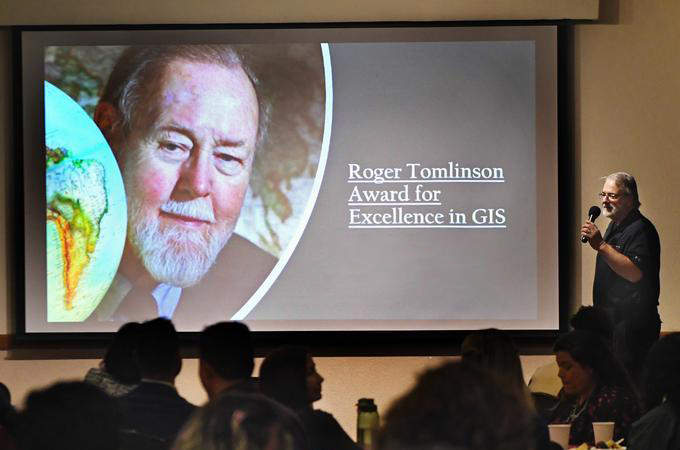
President Krista Newkirk awarded two students with the Roger Tomlinson Prize for Excellence in GIS. Since 2016, the Tomlinson Prize has been awarded to students who have demonstrated strong research and academic capabilities in the field of geographic information science.
The undergraduate prize went to Andrew Sheble ’22. Newkirk noted that faculty were astounded with his skill and initiative in GIS. “[Andrew] is a diligent student with a very high capacity for understanding a broad range of environmental topics, from those in social sciences to life sciences, and for navigating technical tools to explore these issues in deep and meaningful ways,” she said. Sheble’s honor capstone research study examines the correlation between carbon emissions and turfgrass in Los Angeles.
The graduate prize went to James Cabrera ’22, recognizing his motivation, commitment, passion, work habits, and leadership in GIS. “[Cabrera] is a leader who always offers to help fellow students who need support and guidance,” Newkirk said, quoting remarks from GIS faculty members. “His focus on integrity and effective communications set a strong example for others as he provides support and guidance to fellow students.”
Avijit Sarkar, professor of business analytics and operations research in the School of Business & Society, presented the Center for Spatial Business Student Excellence Awards. This was the 10th year the awards have been given, honoring students in the School of Business & Society and the College of Arts and Sciences business programs for their work in GIS. Each year, one student or team of students is selected from undergraduate programs and one from graduate programs.
The undergraduate award went to Ricardo Garavito ’22 for his effective use of location analytics to find the best location for a new Blu Chip Financial Services, LLC office. The project included drivetime and demographic analysis to identify competitor locations and match criteria to real estate websites.
The graduate award went to Pavani Pattipati ’21 and Mahendra Aseri ’21 for their project on the spatial analysis of COVID-19. Their spatial analytics tool assessed the temporal dynamics of COVID-19 in an effort to mitigate the spread of the disease. “This project was so useful, it was adopted and expanded for use by a hospital chain,” noted Center for Spatial Business Director James Pick.
The Center for Spatial Studies also recognized Provost Kathy Ogren as a “spatial champion” in appreciation of her support of spatial education at the U of R and her collegial relationship with the Center.
Using data to tell stories
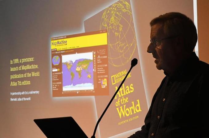
During the keynote address, Esri Storytelling Program Manager Allen Carroll spoke about the importance of using storytelling methods to explain critical issues. “Storytelling is one of the things that really makes cultures work,” he said. “For hundreds of thousands of years, [stories] were essentially the sole means by which culture was passed down from one generation to the next.”
Carroll shared his experiences as a cartographer learning how passionate people are about their stories even in the way geography is labeled. “We got visits once a year of separate [Japanese and Korean delegations], very politely saying that the Sea of Japan should either be called the East Sea, that’s by the Koreans' viewpoint, or the Sea of Japan, from the Japanese viewpoint.”
Carroll also introduced features of StoryMaps that can be used to tell impactful stories. He emphasized the importance of map choreography, a method for moving between geographic information in a way that limits data overload and makes maps dance.
“Just the ability to create a really polished narrative to share is an empowering thing,” Carroll reminded attendees. “There's never been a single species that has the power to essentially destroy our mother planet but also the potential ability to save it and to ensure its continued sustainability. So, I urge us all to want to play our parts to tell stories to inform and to enable.”
Learn more about the Center for Spatial Studies, the Center for Spatial Business, the MS GIS program, the MBA with a concentration in location analytics, and the Spatial Studies minor at the University of Redlands.