
Several examples of studies with Center involvement illustrate the Center’s applied research.
Center for Spatial Business
Research
Thought Leadership in Research on Business, Management, and Related Societal Areas
---
Navigate to Center for Spatial Business | Resources | Research | Education
The Center has had a goal to build leadership in research on spatial business for faculty and students at the university and through collaboration with other universities. The research has been fostered in the courses and curricula of the school, through inspiring meetings, visiting scholars, speaker events and meetings, collaboration through academic research associations, and through interactions with corporations and local and national governments. Esri has been an exceptional partner in research in collaboration, meetings, and consultation from the Center’s beginning onwards.
Student research has been encouraged and dozens of SBS and other students have been engaged in their own research stemming from coursework and as research assistants on faculty-led projects. In many cases, students have co-presented findings and co-authored published papers. The research, in turn, has contributed by being sometimes incorporated into teaching in the school’s courses. For example, research on GIS in US urban areas has been the basis of student learning labs on GIS software.
Among the faculty research focused on GIS for business and society are the following broad research areas:
- Determining the locational cluster groupings and associated social and economic relationships with the sharing economy, for Airbnb in US cities.
- Study of the curricular and educational status, challenges, and opportunities of GIS in business and management schools.
- Study of spatial aspects of urban communities including the flows of people, goods, and services.
- How local and regional governments in the US maintain the locational privacy of personal information.
- Examining the geospatial aspects of renewable energy development and its related socio-economic features
- Study of the locations of medical supply chains.
- Analysis of digital divides and inequalities in the uses of digital information.
- Exploring the relationship of commuting times to work and family conflict.
- Space-time measures of services and Internet activities.
- Student studies of features of California regions, counties, and cities.
Featured Research Projects
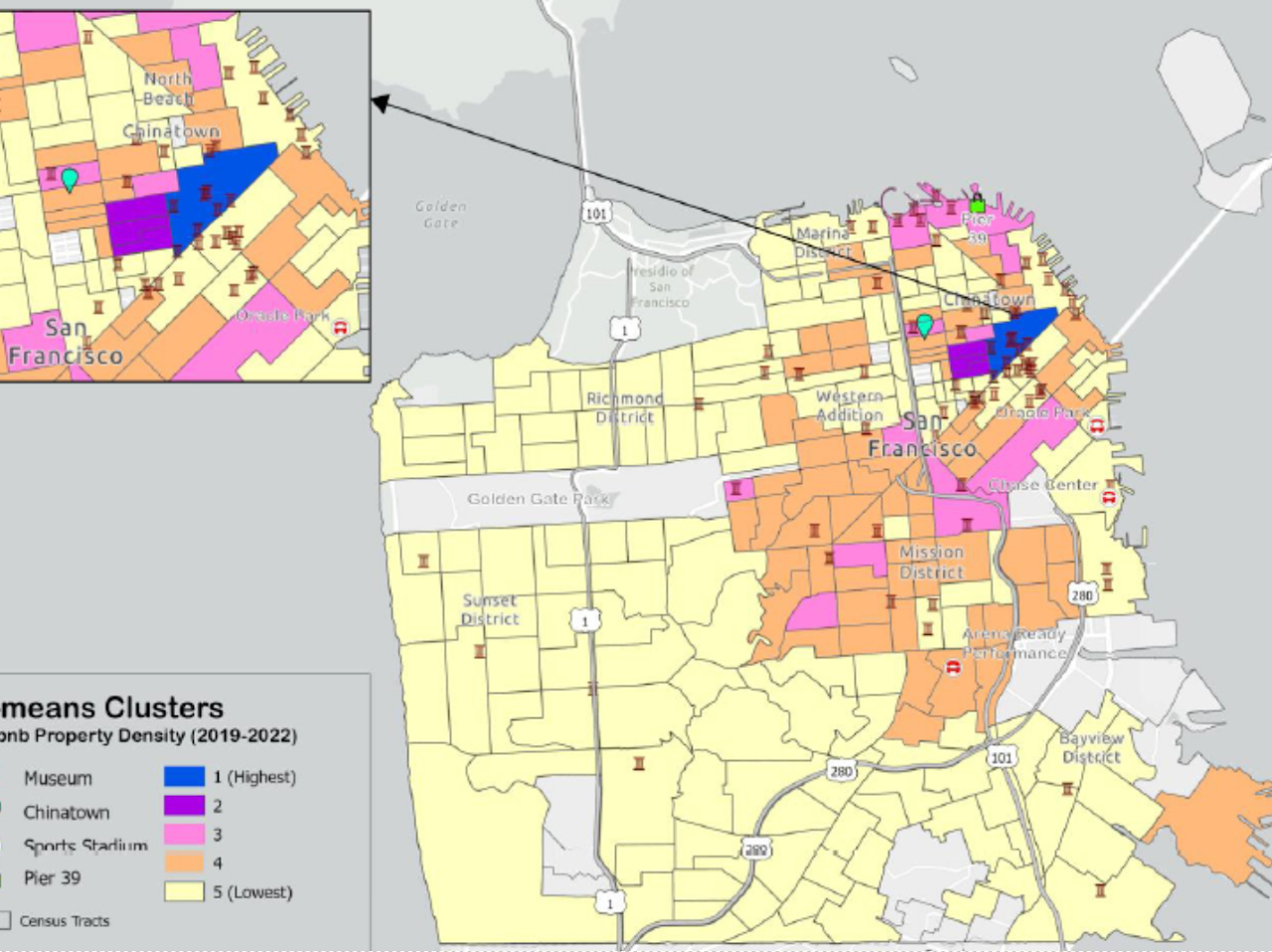
San Francisco
A study applied spatial cluster analysis to determine where Airbnb properties are located in the City of San Francisco. The results can be helpful to city planners in planning and regulation of housing and visiting accommodations for the city.Airbnb property densities, San Francisco, 2019-2022. A. Sarkar, J. Pick, and S. Jabeen, IIGI, 2023
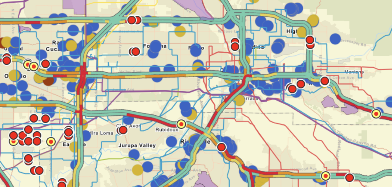
Inland Empire
A team of undergraduate students gathered extensive information on existing EV charging stations in the Inland Empire region of California (shown in blue). Using geo-modeling, they estimated the optimal locations for the location of future EV charging stations by block group (shown in red).Promising block group location for new EV charging stations Inland Empire (red symbols)
Undergraduate research, F. Frias, G.Gardner, J.Mullen, 2023
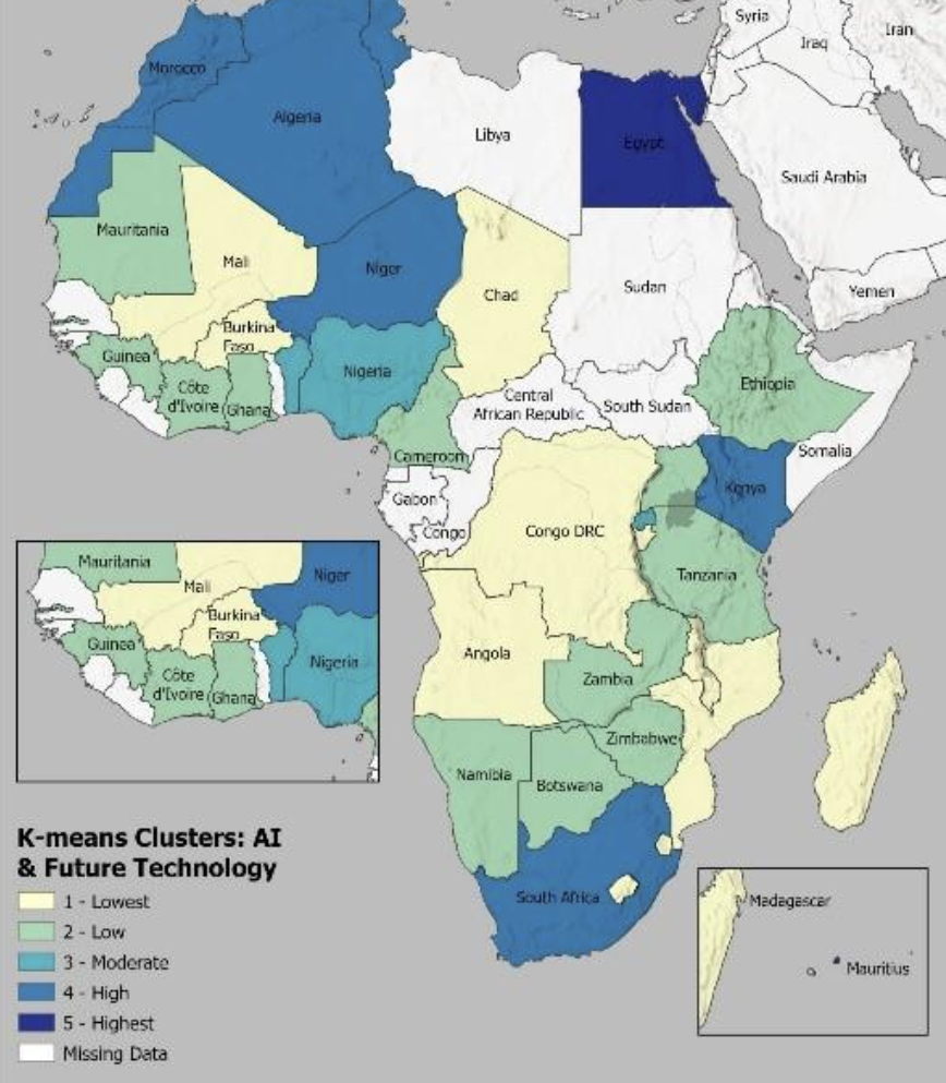
Africa
AI is beginning to spread across Africa, even though that continent has been the slowest to develop its use of technologies. A faculty research study based on recently available data indicates that AI and other future technologies are the highest in Egypt and high in some other largely coastal nations, but low or unreported in the center of the continent. The study provides justifications and reasoning for why the coastal areas are the highest. It offers suggestions on how the technologies may be more equitably distributed in the future.