Since 1999, the global geographic information systems (GIS) community has been celebrating GIS Day, the midpoint of Geography Awareness Week established by presidential proclamation in 1987. The annual week-long event, centered around GIS Day on November 18, provides an international forum for geospatial technology users to showcase applications and demonstrate the impact of GIS on communities around the world.
As a result of the COVID-19 pandemic, GeoWeek at the University of Redlands looked different than it has in years past, but participants brought plenty of enthusiasm and curiosity to the virtual events hosted by the Center for Spatial Studies and the Center for Spatial Business.
“It’s important to celebrate significant events, even in a pandemic,” says Center for Spatial Studies Director Steve Moore. “This year, GIS Day and GeoWeek gave us something to focus on and lent a bit of normality to our very disrupted lives. Given the stress of the pandemic and the political situation in the United States, it’s encouraging to lift up the positive things in our lives.”
An array of events
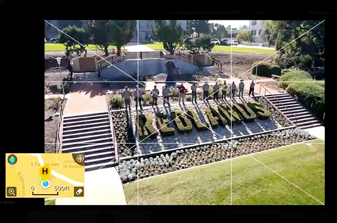
On GIS Day, community members joined together in a virtual humanitarian mapathon, followed by a live streamed drone flight featuring a bird’s eye view of the main Redlands campus. Both events, says Director of Spatial Technology Nathan Strout, were successful.
“The mapathon is always a favorite of mine, and it worked remarkably well as a virtual event,” he says. “Our project involved mapping a district in Uganda that has been hit especially hard by COVID-19 in order to support relief efforts by the Red Cross and other agencies. We met virtually as a group to introduce the project, learn some of the tools, and get started; that live meeting was streamed and recorded and others participated throughout the day. Collectively, we mapped hundreds of buildings and several miles of road.”
The drone flight was a group effort and gave students, who have been studying remotely this semester, the opportunity to revisit the beauty of the main Redlands campus. “Nate did a wonderful job of putting it together,” says Moore. “[Director of Alumni and Community Relations] Shelli Stockton also got the word out so that faculty, staff, and administrators could cheer on the flight. Having [University Chaplain] John Walsh and [Campus Diversity and Inclusion Assistant Director] Peter Tupou in the chapel belltower was a particular treat. I also need to note that [Spatial Resources Manager] Lisa Benvenuti did a stellar job getting everything organized for the day.”
Later in the day, MS GIS students Morghan Montez ’20, Jingyi Huang ’20, and Henry Duran Chacon ’20 put their work on display during the virtual MS GIS Colloquium. “They were able to apply modern technologies and methods to solve some important real-world issues such as ocean pollution and groundwater contamination,” says Professor and MS GIS Program Chair Fang Ren, who appreciates the opportunity GeoWeek offers to bring students together to share GIS interests and research. “I am impressed by the quality of their work.”
Never more important than now
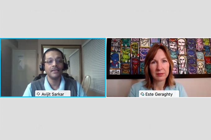
The following day, the Center for Spatial Business hosted a virtual speaker event, in which Esri Chief Medical Officer Este Geraghty spoke about how GIS professionals around the world are using geospatial technology to develop and support COVID-19 response and recovery efforts. During her talk, Geraghty identified the patterns that she and her colleagues have seen emerge in recent public health GIS usage and explained why the geographic lens is critical in the age of COVID-19.
“Mapped information has been front and center during the pandemic—you might make the argument that GIS has actually never been more important than it is right now,” said Geraghty, recalling the Johns Hopkins University COVID-19 dashboard, which utilizes Esri’s GIS tools and has received numerous awards since the onset of the pandemic.
The dashboard’s utility and popularity have increased the value of GIS on a global scale, promoted data sharing, exposed gaps in public health data, and developed expectations for the collection and display of data in real-time. Different jurisdictions and organizations around the world have taken to mapping COVID-19 with varying levels of granularity, making for an interesting and valuable case study.
Geraghty revealed four patterns that she and her colleagues on Esri’s Health and Human Services team have seen emerge in GIS usage recent months: mapping and monitoring disease, strategic planning, indoor space management, and analysis of relationships and gaps in data. With the help of geospatial tools, testing sites and food resources have been expanded, population demands for different services have been determined, sanitization and safety operations have been improved, and capacities have been forecasted in order to help healthcare institutions prepare for larger caseloads. More recently, Geraghty said, data has been collected and managed in order to answer questions about contact tracing and vaccine distribution.
In closing, Geraghty touched on the lessons that the GIS community has learned in the face of disaster—from 9/11 to the 2018 Camp Fire in California—noting that each event has led to increased levels of data sharing and better decision-making.
“We need to incorporate these lessons that we’ve learned from COVID-19 into our organizational workflows in a way that will prepare us for whatever happens next,” she said. “Let’s keep the innovation going, because it has never really been enough to simply collect the dots. Technologies like GIS support health and help us to connect the dots in ways that inform, inspire, and instigate changes that will make us all healthier.”
Learn more about spatial studies at the University of Redlands.