Location, the sense of “place,” influences how we work, play, and live. At the University of Redlands, the campus community celebrates Geographic Awareness Week (GeoWeek) each November to examine “place” and show the community at large how geography and spatial studies play a role in scenarios from games to disasters.
Established in 1987 by President Ronald Reagan, GeoWeek has been celebrated at Redlands for the past five years as spatial studies continue to evolve on campus.
“The University of Redlands is a spatial university—spatial thinking is integrated into a broad spectrum of coursework, research, and administrative functions throughout the institution,” said Steven Moore, director of the Center for Spatial Studies at U of R. “GeoWeek is significant because it shines a light on geography.”
Virtual travel
Activities began in the University’s “Makerspace” located in the Fletcher Jones Computer Center on the first level of the Armacost Library. On this day, the 3D printer was busy “cloning” U of R mascot Addie from a 3D scan, while visitors were invited to travel the world using virtual reality. Using “Wander,” a program that uses Google Street View images for a virtual reality experience, visitors including Julia Smyth ’22 were able to visit dream locations.
“I didn’t realize how much detail it would have,” said Smyth, who minors in GIS. “I am hoping to study abroad in Dublin, Ireland, so it’s cool to be able to see it like this.”
Iyan Sandri, computer lab supervisor, added, “The program also has a feature that lets you time travel. There can be multiple 360-degree images associated with a location. Wander uses the images’ timestamps and a menu option to let users jump between the images to see what the space looked like historically (earliest “history” about 2008).”

Students in spatial studies use the Makerspace to explore and understand the world, said Iyan (who asked we use his first name): “Last year some research students from the chemistry program used the Makerspace to fly over their research site. In doing this flyover through VR, they were able to see the mountains of their site from a different perspective (and in 3D). The chemistry students were then able to connect/hypothesize how the data from their samples were affected by the geography of the site.”
GIS galore
Makerspace fun was followed Tuesday evening with a lecture from Lawrence Joseph, an expert in business geography and locational intelligence, part of the U of R’s Center for Spatial Business Speaker Series. Joseph discussed how spatial thinking coupled with the application of Big Data can provide a competitive edge in decision-making on locational deployment. He also shared applications and best practices for market research, influencing techniques, and the associated evaluation of individual sites.
Wednesday was Geographic Information Systems (GIS) Day, a nationally recognized day since 1999. On campus, students and faculty demonstrated technology and assisted with hands-on activities in Hunsaker Plaza, followed by more formal project presentations by students at the Master of Science in GIS colloquium.
In the Office of Career and Professional Development (OCPD), two Esri campus recruiters executed a Career Studio takeover. “They helped students with resume reviews, and shared insider tips on the application process regarding what to expect, how to prepare, and what Esri looks for in candidates,” said Kelly Dries, OCPD executive director. “We had 33 students (graduate and undergraduate) meet one-on-one with the recruiters.”
Off-campus, Moore brought GIS Day to four local high schools. “Students were interested in GIS, mapping, careers at Esri, and spatial programs at U of R,” Moore said. “Most exciting to the students was a spatial game in which students identified in an online GIS survey where they would most want to go on an all-expenses-paid vacation. On a large monitor or projected image, the results were displayed live on a world map. Competition got intense as each school attempted to map the most ‘bucket list’ points.”
Mapathon and more
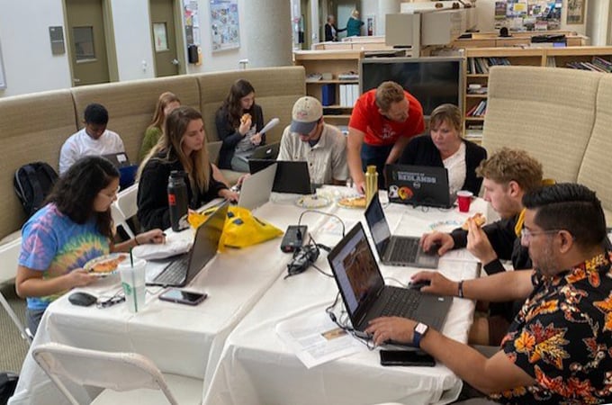
On Thursday, a group met in the GIS Lounge at Lewis Hall for a “Humanitarian Mapathon.” Through Tasking Manager, a mapping tool designed and built for the Humanitarian OpenStreetMap Team's collaborative mapping process in OpenStreetMap.org, participants worked on a mapping project for Kenya, which in October suffered mass devastation from floods.
“The tools are easy and the training is quick,” said Nate Strout, director of spatial technologies for the Center for Spatial Studies.
“The most vulnerable places in the world are largely unmapped in terms of basic infrastructure such as roads, waterways, and buildings,” Strout said. “This is information that aid workers and first responders desperately need, so many groups turn to this form of crowd-sourced data.”
The map is coded to reveal which areas still need work. Once the initial mapping is completed, it is verified by someone familiar with the area. Once verified, the map helps humanitarian organizations reach those who need aid or supplies.
The week wrapped up on Friday with a GeoWeek disc golf tournament on the U of R 9-hole course.
“We live in an increasingly interconnected world faced with challenging global problems,” Moore said. “Geography, spatial analysis, remote sensing, artificial intelligence, and other technologies and ways of thinking can help solve these problems.”
Learn more about the Center for Spatial Studies, the Center for Spatial Business, the spatial studies minor, and the MS GIS program at the University of Redlands.