Featured projects from the University of Redlands spatial community
Mapping Metal Music
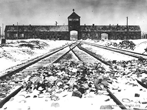
Few genres of popular music are as polarizing as metal (aka "Heavy Metal"). Depending on the listener, it can induce cringes, derisive laughter, or bliss. Through its sound, lyrics, and visual aesthetics, metal has attracted millions of fans over the last five decades due to its transgressive nature of pushing musical envelopes and challenging social and cultural mores leading to a sense of empowerment. It can exhibit escapist and cathartic qualities for those feeling trapped by the druggery of daily life. From its very beginnings it has also engaged with issues like inquality, war, history, mental health, and more recently, the environment. It is a form of music marked by a level of intentionality that is hard to ignore regardless of one's reaction to it.